Utah is a land of contrasts, where red rock canyons meet alpine forests, and ancient geological formations tell stories millions of years in the making. From the iconic arches of Moab to the otherworldly hoodoos of Bryce Canyon, Utah offers some of the most spectacular landscapes in North America. Whether you’re an adventure seeker, photography enthusiast, or simply looking to reconnect with nature, this comprehensive guide will help you discover the top 10 places to visit in Utah, along with hidden gems, practical travel tips, and everything you need to plan your perfect Utah adventure.
Utah boasts five magnificent national parks, collectively known as the “Mighty Five,” along with numerous state parks, monuments, and recreation areas. The state’s unique geography creates landscapes unlike anywhere else on Earth, shaped by millions of years of erosion, uplift, and natural forces. Beyond the parks, Utah offers vibrant cities, world-class skiing, rich cultural experiences, and some of the darkest night skies in the country, perfect for stargazing.
The accessibility of Utah’s natural wonders makes it an ideal destination for travelers of all types. Many of the state’s top attractions are within a day’s drive of each other, allowing you to experience diverse ecosystems and landscapes in a single trip. From the desert lowlands to mountain peaks exceeding 13,000 feet, Utah’s elevation range creates distinct climate zones and ecosystems that support an incredible variety of plant and animal life.
TL;DR – Quick Links to the Top 10 Places to Visit in Utah
- Zion National Park (Google Maps)
- Bryce Canyon National Park (Google Maps)
- Arches National Park (Google Maps)
- Canyonlands National Park (Google Maps)
- Monument Valley (Google Maps)
- Capitol Reef National Park (Google Maps)
- Dead Horse Point State Park (Google Maps)
- Goblin Valley State Park (Google Maps)
- Bonneville Salt Flats (Google Maps)
- Salt Lake City & Temple Square (Google Maps)
1. Zion National Park
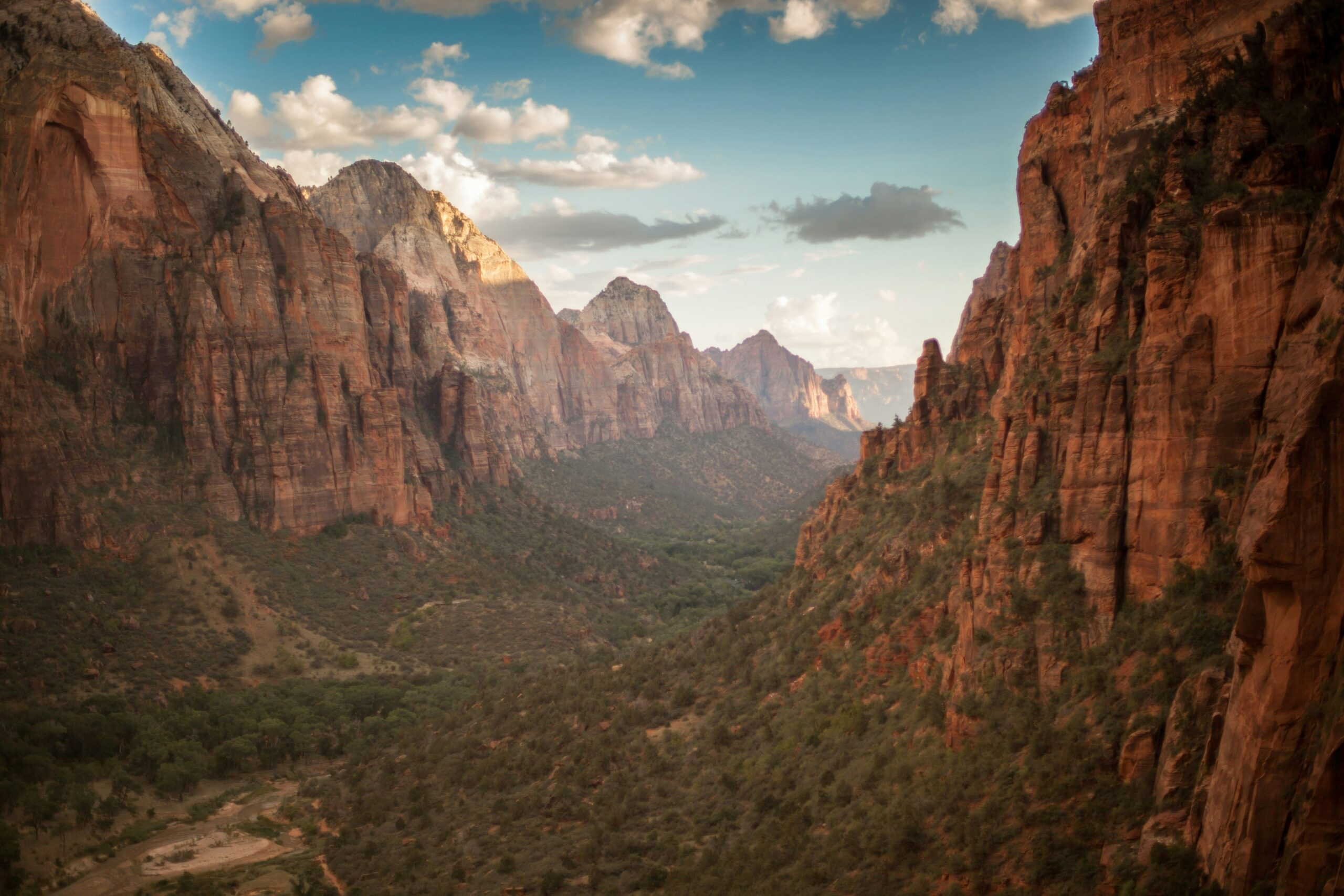
Zion National Park stands as Utah’s most visited national park, drawing over 4.5 million visitors annually to its towering sandstone cliffs and narrow slot canyons. The park’s main attraction, Zion Canyon, features vertical walls that rise to 2,000 feet from the canyon floor, creating one of the most dramatic landscapes in the American Southwest.
What Makes Zion Special
The Virgin River carved Zion Canyon through layers of Navajo Sandstone over millions of years, creating the spectacular scenery visitors see today. The canyon’s unique orientation allows sunlight to penetrate deep into the gorge, illuminating the red and cream-colored walls in constantly changing patterns throughout the day. The interplay of light and shadow on the canyon walls creates a photographer’s paradise, with new compositions revealing themselves hourly.
Zion’s ecological diversity amazes first-time visitors. The park encompasses multiple life zones, from desert lowlands to high plateaus, supporting over 900 plant species and 78 mammal species. Riparian zones along the Virgin River create lush oases in the desert, where cottonwood trees provide shade and habitat for countless bird species.
Must-Do Activities
Angels Landing remains Zion’s most famous hike, though it requires a permit obtained through a lottery system. This challenging 5.4-mile round-trip trail features a final half-mile section with chains bolted into the rock, where hikers navigate a narrow ridge with 1,000-foot drop-offs on both sides. The panoramic views from the summit encompass the entire Zion Canyon and justify the strenuous effort required to reach the top.
The Narrows offers a completely different Zion experience, where hikers wade through the Virgin River between towering canyon walls that narrow to just 20 feet wide in places. This bottom-up hike can be as short or long as you choose, with most day hikers turning around at Big Springs or Wall Street. The water temperature remains cold year-round, typically between 40-50°F, so proper footwear and preparation are essential.
For those seeking less crowded experiences, the Observation Point trail via the East Mesa approach provides stunning views overlooking Angels Landing from above. This 8-mile round-trip hike avoids the crowds and permit requirements of Angels Landing while offering equally spectacular vistas.
The Canyon Overlook Trail serves as an excellent introduction to Zion for families or those with limited time. This easy one-mile round-trip hike provides dramatic views of lower Zion Canyon and Pine Creek Canyon without the difficulty of longer trails.
Travel Tips for Zion
The park operates a mandatory shuttle system from March through November, which reduces traffic congestion and protects the canyon environment. Parking at the visitor center fills early, often by 7 AM during peak season, so arrive early or consider staying in Springdale and walking to the shuttle stop.
Summer temperatures in Zion Canyon frequently exceed 100°F, making early morning and evening the best times for hiking. Spring (April-May) and fall (September-October) offer more moderate temperatures and arguably the best hiking conditions. Winter brings solitude and occasional snow-dusted landscapes, though some high-elevation trails may be inaccessible.
2. Bryce Canyon National Park
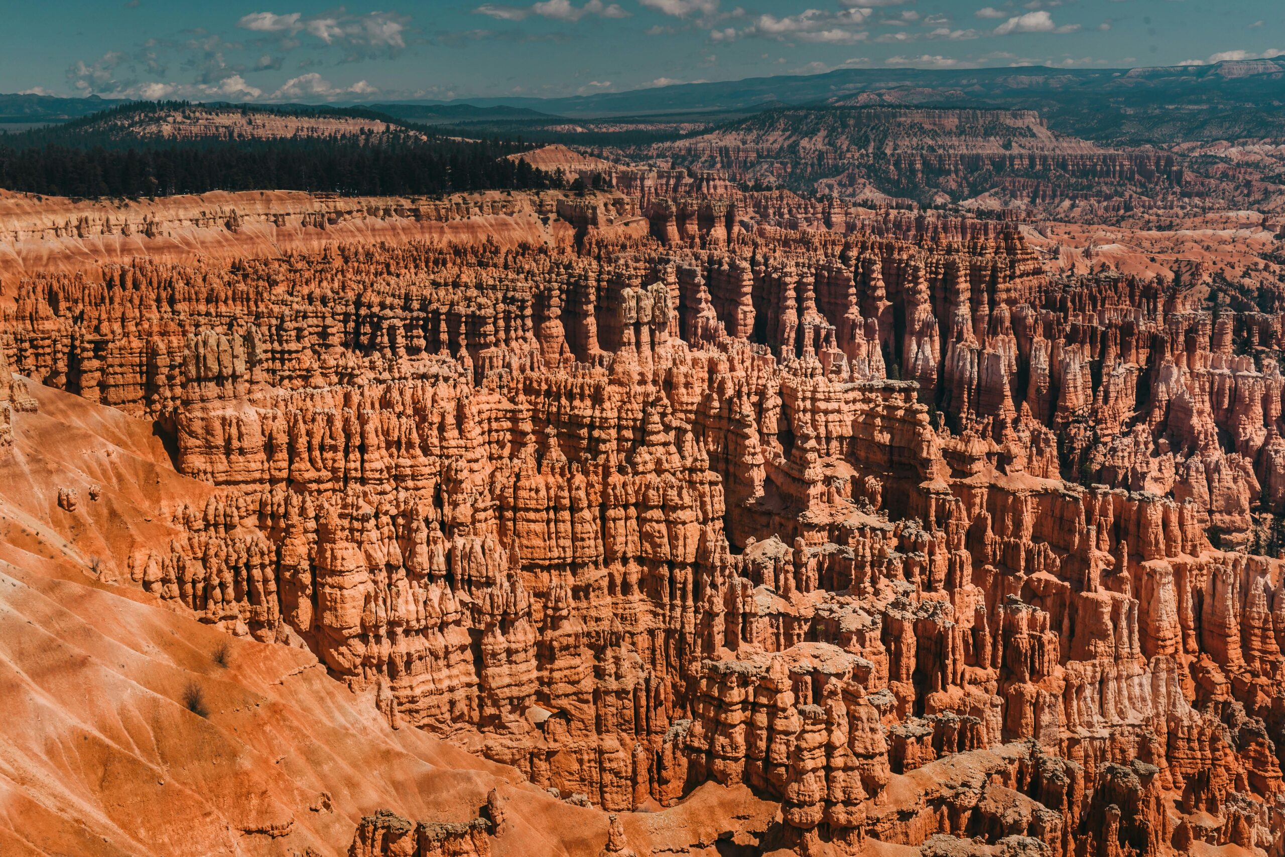
Bryce Canyon National Park protects the largest collection of hoodoos, irregular columns of rock in the world. Despite its name, Bryce Canyon is not actually a canyon but rather a series of natural amphitheaters carved into the edge of the Paunsaugunt Plateau. The park’s unique geology and high elevation create a landscape that appears almost surreal, especially at sunrise and sunset when the rocks glow in shades of orange, red, and pink.
Understanding Bryce’s Geology
The hoodoos of Bryce Canyon formed through a geological process called frost wedging. Water seeps into cracks in the limestone rock during the day, then freezes at night (Bryce experiences over 200 freeze-thaw cycles per year). As water freezes, it expands, gradually breaking the rock apart. Over millennia, this process carved the intricate spires and fins visible today.
The rocks at Bryce Canyon contain high concentrations of iron and manganese, which oxidize to create the vibrant colors that make the park so photogenic. Different mineral compositions create varying colors within the same formation, adding to the visual complexity of the landscape.
Best Viewpoints and Hikes
Sunrise Point and Sunset Point serve as the park’s most popular overlooks, offering spectacular views into Bryce Amphitheater. Despite their names, both viewpoints are excellent for both sunrise and sunset viewing. Sunrise Point faces east, providing front-row seats to the sun illuminating the hoodoos from the side, while Sunset Point offers broader views of the amphitheater.
Bryce Point sits at a higher elevation than Sunrise and Sunset Points, providing a more comprehensive view of the amphitheater and the aqua-colored cliffs beyond. This viewpoint is particularly stunning in winter when snow covers the hoodoos, creating a contrast between the white snow and red rock.
The Navajo Loop and Queen’s Garden Trail combination creates the park’s most popular hiking route. This 2.9-mile loop descends into the amphitheater, allowing hikers to walk among the hoodoos and experience their scale from ground level. The trail passes through Wall Street, a narrow canyon lined with tall Douglas firs, and features several famous formations, including Thor’s Hammer and Queen Victoria.
For a more challenging experience, the Peekaboo Loop Trail (5.5 miles) ventures deeper into the amphitheater and receives fewer hikers than the Navajo Loop. This trail provides different perspectives on the hoodoos and includes sections where you can see through natural arches to hoodoos beyond.
The Fairyland Loop (8 miles) offers the most comprehensive tour of Bryce’s hoodoos with minimal crowds. This strenuous trail explores the northern section of the park and can be completed as a day hike or overnight trip with a backcountry permit.
Stargazing at Bryce
Bryce Canyon ranks among the darkest places in the United States, earning designation as an International Dark Sky Park. The park’s high elevation (8,000-9,000 feet) and remote location create ideal conditions for viewing the Milky Way, planets, and deep-sky objects. Park rangers lead astronomy programs throughout the year, providing telescopes and expertise to help visitors explore the night sky.
3. Arches National Park
Arches National Park contains over 2,000 natural stone arches, the highest concentration of natural arches in the world. Located near Moab in eastern Utah, the park’s landscapes have been featured in countless films, advertisements, and photographs, making it one of the most recognizable natural areas in America.
The Formation of Natural Arches
Arches form through a specific geological process that requires particular rock types and conditions. The park’s arches developed in Entrada Sandstone, which overlies a salt bed deposited 300 million years ago. The weight of overlying rock caused the salt to liquefy and flow, creating domes and valleys on the surface. Over time, water infiltrated cracks in the sandstone, freezing and thawing to widen the cracks into fins. Eventually, sections of these fins collapsed, leaving arches behind.
The same processes that create arches also destroy them. Several arches have collapsed in recent decades, including Wall Arch in 2008, reminding visitors that these formations are temporary features in geological terms.
Iconic Arches to Visit
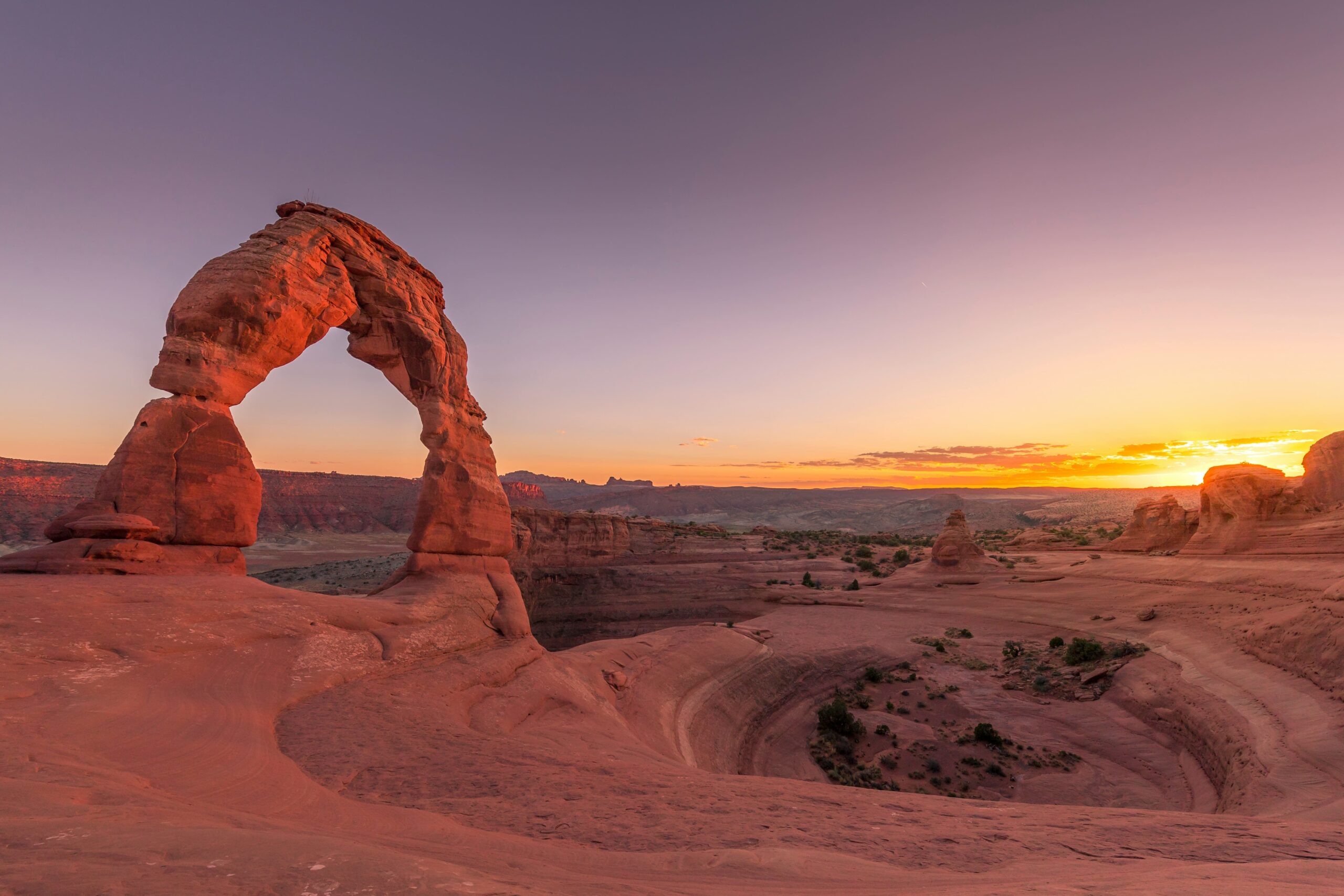
Delicate Arch serves as Utah’s most famous landmark, appearing on license plates, postage stamps, and tourism materials worldwide. The three-mile round-trip hike to reach Delicate Arch gains 480 feet of elevation and crosses slickrock with minimal shade, making it challenging during summer heat. However, standing beneath this 65-foot-tall freestanding arch at sunset, watching it glow orange and red against the La Sal Mountains, creates an unforgettable experience.
For those unable to hike to Delicate Arch, the Lower Delicate Arch Viewpoint offers a distant but still impressive view after a 100-yard walk from the parking area. The Upper Viewpoint requires a half-mile walk but provides a better angle for photographs.
Landscape Arch spans 306 feet, making it the longest natural arch in North America. The one-mile walk to reach Landscape Arch follows a relatively flat trail suitable for most fitness levels. The arch appears impossibly thin, with some sections only six feet thick, and geologists predict it may collapse within our lifetimes.
Double Arch features two spans that share the same stone foundation, creating a unique formation visible after a short half-mile walk. The arches reach heights of 112 feet and 105 feet, and visitors can walk underneath and even climb partway up the formation.
The Windows Section contains several large arches accessible via short trails, making it ideal for families or those with limited time. North Window, South Window, and Turret Arch can all be visited on a one-mile loop trail.
Navigating Arches National Park
Arches National Park implemented a timed entry reservation system to manage overcrowding, particularly during peak seasons (April-October). Reservations are required for entry between 7 AM and 4 PM during these months and must be booked in advance through Recreation.gov. Some same-day reservations become available at 6 PM the day before entry.
The park’s main road extends 18 miles from the visitor center to Devil’s Garden, with turnoffs leading to various arches and viewpoints. Cell phone service is unreliable throughout the park, so download maps and information before arrival.
Summer temperatures at Arches regularly exceed 100°F, with ground temperatures on slickrock surfaces reaching 140°F or higher. Early morning visits (before 9 AM) or late afternoon explorations provide more comfortable conditions for hiking.
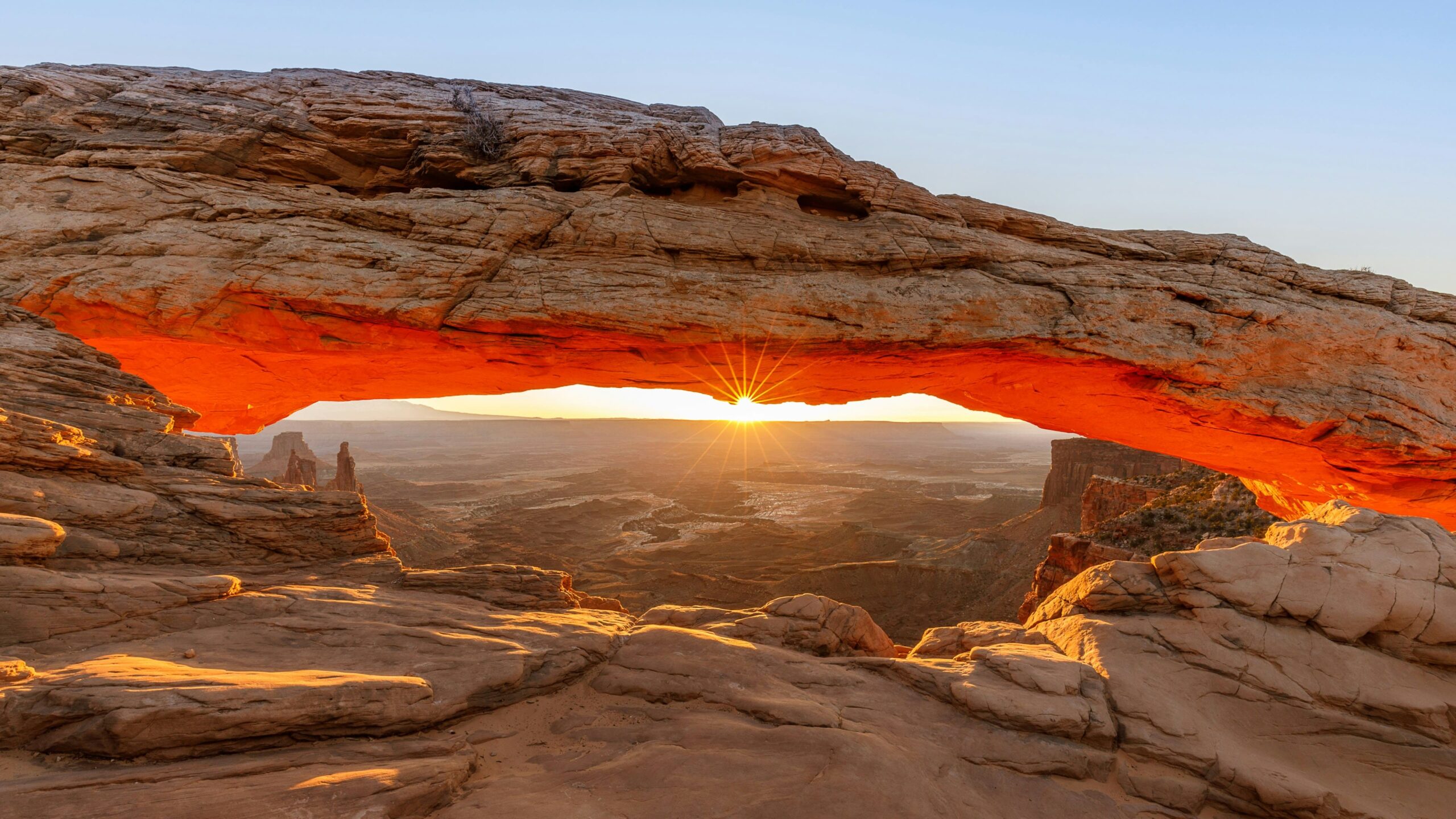
4. Canyonlands National Park
Canyonlands National Park protects 337,598 acres of Colorado Plateau wilderness, carved by the Colorado River and its tributary, the Green River. The park is divided into four distinct districts: Island in the Sky, The Needles, The Maze, and the rivers themselves, each offering different landscapes and experiences.
Island in the Sky District
Island in the Sky serves as the most visited and accessible district, located just 30 minutes from Moab. This mesa-top district sits 1,000 feet above the surrounding terrain, providing expansive views of deep canyons, distant mountain ranges, and the convergence of the Green and Colorado Rivers.
The Grand View Point Overlook, located at the end of the main park road, offers 100-mile views across layer upon layer of canyon country. The overlook provides perspectives on the White Rim below, the Needles District in the distance, and the Henry Mountains on the horizon. A two-mile round-trip trail extends from the parking area along the mesa edge, offering constantly changing viewpoints.
Mesa Arch has become one of the most photographed arches in Utah due to its unique position at the edge of a 500-foot cliff. Sunrise photographers arrive hours before dawn to capture the arch glowing orange as the rising sun illuminates it from below. The short half-mile round-trip trail makes Mesa Arch accessible to all visitors.
The White Rim Road creates a 100-mile loop through stunning canyon country 1,000 feet below the Island in the Sky mesa. This primitive road requires a four-wheel-drive, high-clearance vehicle and typically takes 2-3 days to complete. Mountain bikers can also ride the White Rim, though support vehicles are recommended for carrying camping gear and water.
The Needles District
The Needles District, located in the southeastern portion of the park, features colorful spires of Cedar Mesa Sandstone that gave this area its name. This district receives fewer visitors than Island in the Sky but offers more opportunities for hiking, backpacking, and solitude.
The Joint Trail provides an exciting 11-mile loop that squeezes through narrow cracks between rock walls, requiring hikers to navigate sections where the passage narrows to shoulder width. Combined with the Chesler Park loop, this hike explores some of the Needles’ most spectacular terrain.
Druid Arch, accessible via a 10-mile round-trip hike, resembles formations at Stonehenge, hence its name. The trail gains 1,400 feet of elevation but rewards hikers with views of this massive arch set against a backdrop of red rock walls.
The Needles District requires more planning than Island in the Sky, as services are limited. The nearest town, Monticello, lies 50 miles away. Visitors should carry plenty of water, food, and supplies, as no water is available in the park beyond the visitor center.
The Maze District
The Maze District ranks as one of the most remote areas in the lower 48 states, requiring significant off-road driving to access and offering no services. This district attracts experienced backcountry travelers seeking true wilderness experiences. The Maze is not appropriate for casual visitors, but those who make the effort discover remarkable solitude and pristine landscapes.
5. Monument Valley
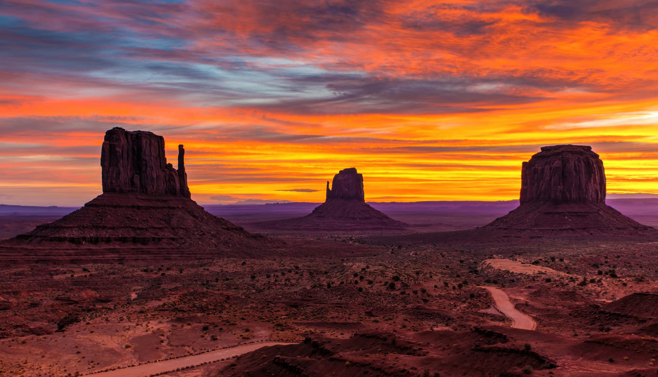
Monument Valley, though technically straddling the Utah-Arizona border, represents an iconic symbol of the American West. The Navajo Nation owns and operates this tribal park, where massive sandstone buttes and mesas rise to 1,000 feet from the valley floor, creating the landscapes that defined Western films for generations.
Cultural Significance
Monument Valley holds deep spiritual significance for the Navajo people, who call this area Tse’Bii’Ndzisgaii, “Valley of the Rocks.” The Navajo Nation has inhabited this region for centuries, and many families still live traditional lifestyles within the valley, herding sheep and maintaining their connection to the land.
Visiting Monument Valley provides opportunities to support Navajo-owned businesses and learn about Navajo culture and history. Tribal park fees support the Navajo Nation, and hiring Navajo guides for backcountry tours provides income to local families while offering deeper insights into the area’s cultural and natural history.
Exploring Monument Valley
The 17-mile Valley Drive loop road provides access to the park’s most famous viewpoints, though the unpaved road can be rough and challenging for low-clearance vehicles. The drive passes iconic formations, including East and West Mitten Buttes, Merrick Butte, and the Three Sisters, with numerous pullouts for photographs.
Many areas of Monument Valley remain restricted to visitors without Navajo guides, protecting both the landscape and the privacy of families living in the valley. Guided tours, offered by numerous Navajo operators, provide access to areas unavailable to independent travelers, including ancient rock art sites, natural arches, and remote viewpoints. These tours range from short 2-3 hour trips to full-day excursions and overnight camping experiences.
The View Hotel, operated by the Navajo Nation, offers the only accommodation within the tribal park boundaries. Rooms feature floor-to-ceiling windows facing the monuments, providing sunrise and sunset views from the comfort of your room. The hotel’s restaurant serves traditional Navajo dishes alongside conventional American fare.
6. Capitol Reef National Park
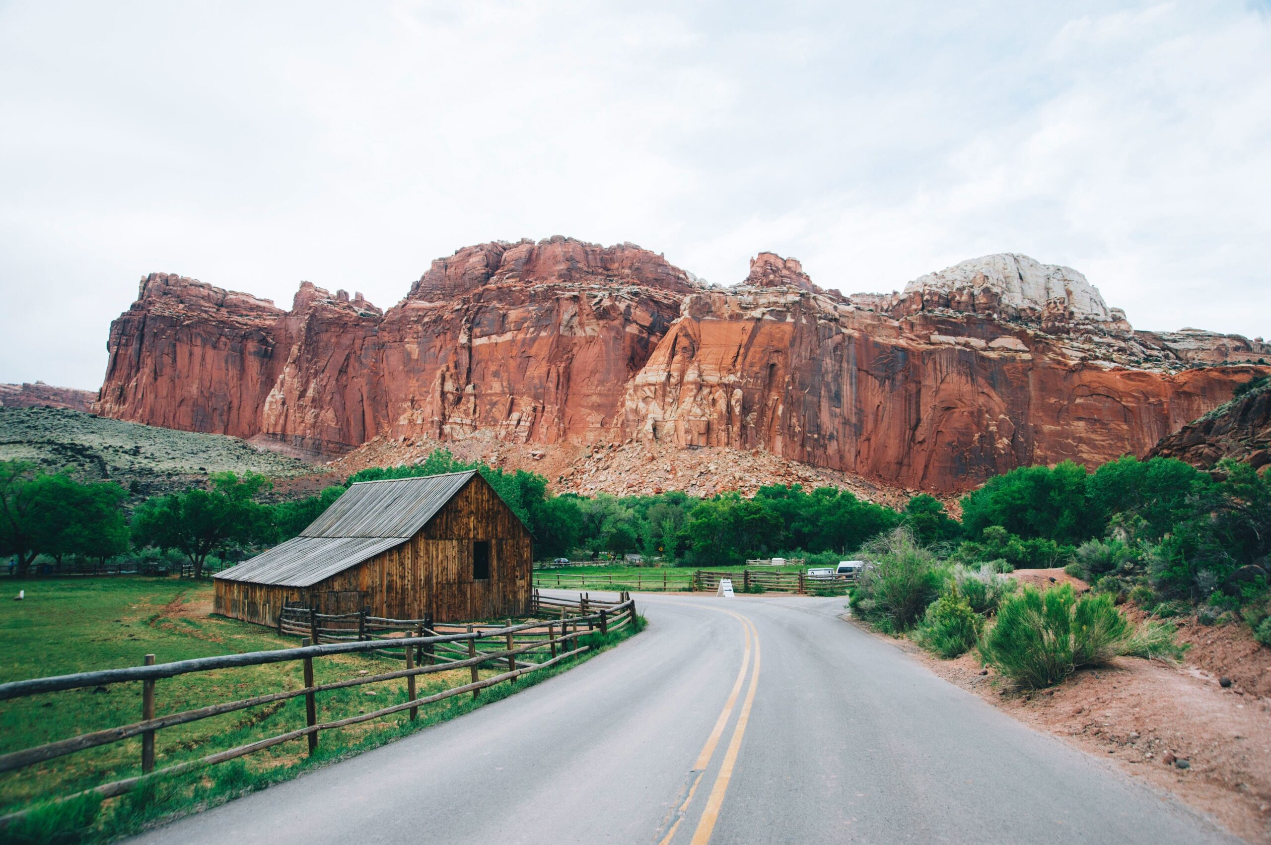
Capitol Reef National Park, the least visited of Utah’s Mighty Five, protects the Waterpocket Fold, a 100-mile-long wrinkle in the Earth’s crust that exposes rock layers dating back 270 million years. This geological monocline creates dramatic cliffs, canyons, domes, and bridges in a rainbow of colors.
A Living History
Unlike Utah’s other national parks, Capitol Reef contains significant human history alongside its geological wonders. Mormon pioneers settled the Fruita area in the 1880s, planting orchards that still produce fruit today. The National Park Service maintains these historic orchards, and visitors can pick apples, peaches, pears, and apricots during harvest season (typically June through October) for a small fee.
The Fruita schoolhouse, Gifford Homestead, and other historic buildings provide glimpses into pioneer life. The Gifford Homestead operates as a museum and store selling freshly baked pies, a Capitol Reef tradition that has delighted visitors for decades.
Scenic Drives and Hikes
The park’s main scenic drive extends 21 miles from the visitor center into the heart of the Waterpocket Fold. This maintained dirt road (passable for most vehicles in dry weather) passes colorful badlands, towering cliffs, and narrow canyons. The road ends at Capitol Gorge, where pioneers carved a wagon route through solid rock.
Hickman Bridge Trail (1.8 miles round-trip) provides an excellent introduction to Capitol Reef’s geology and ecology. This moderate hike passes a Fremont Culture granary before reaching a 133-foot natural bridge. Interpretive signs along the trail explain the area’s geological formation and ecological zones.
For a more strenuous adventure, the Cassidy Arch Trail (3.5 miles round-trip) climbs 670 feet to reach a massive arch named for outlaw Butch Cassidy, who reportedly hid in the area. The trail offers sweeping views of Grand Wash and the surrounding landscape.
The Cathedral Valley Loop, a 60-mile backcountry road through the park’s northern district, showcases enormous monoliths rising from the valley floor. This route requires a high-clearance 4WD vehicle and includes a river ford that can be impassable during high water. The remote landscape and minimal crowds make this one of Utah’s most rewarding backcountry drives for properly equipped travelers.
Petroglyphs and Rock Art
Capitol Reef contains numerous examples of ancient Fremont Culture rock art, including the extensive panel along Highway 24 near the visitor center. The Fremont people inhabited this area from approximately 300 to 1300 CE, hunting, gathering, and farming the river bottomlands. Their petroglyphs depict anthropomorphic figures, bighorn sheep, and geometric designs, providing insights into their culture and beliefs.
7. Dead Horse Point State Park
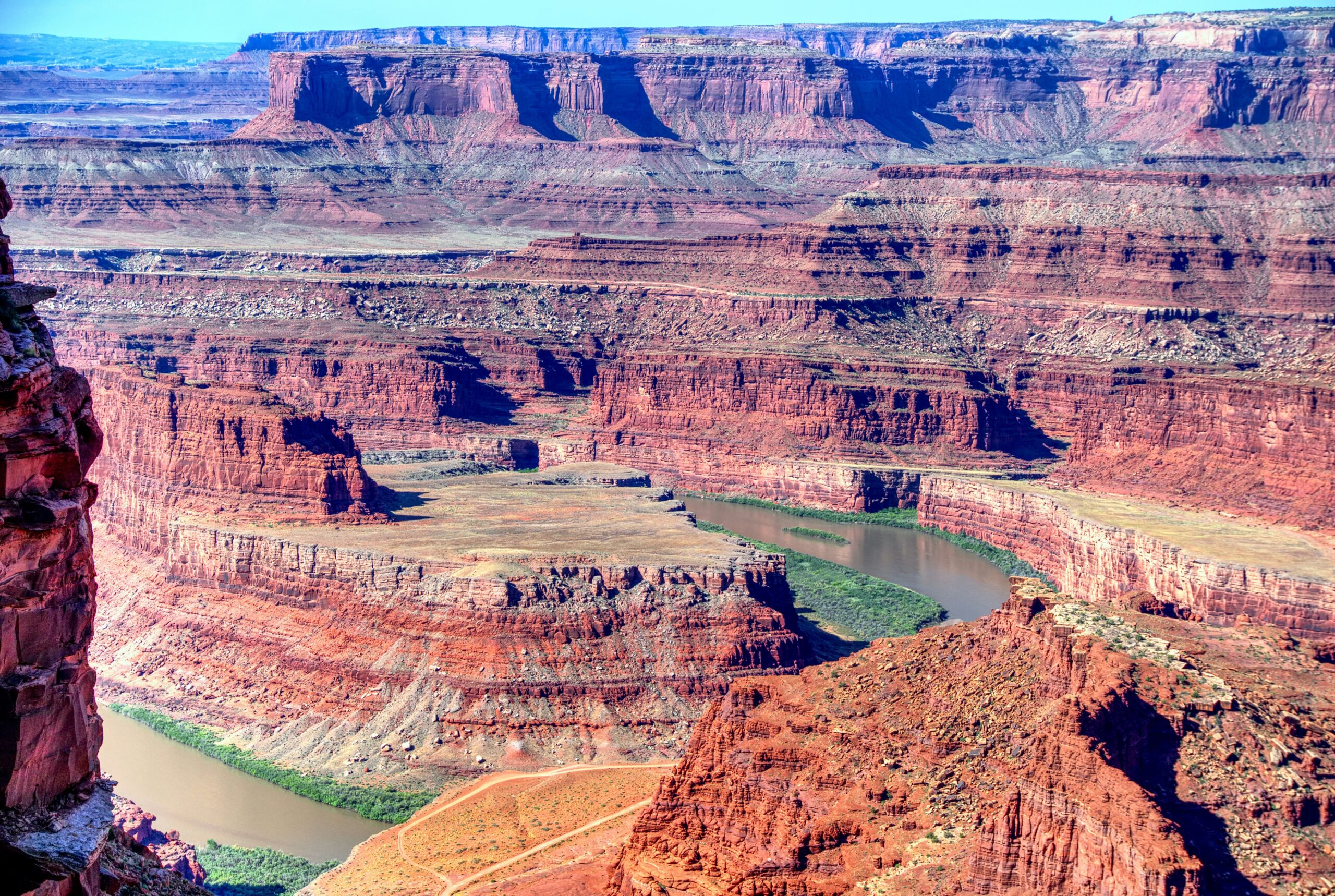
Dead Horse Point State Park, located 30 minutes from Moab, rivals any national park for spectacular canyon views. The park sits 2,000 feet above a gooseneck in the Colorado River, providing 100-mile panoramic views that encompass Canyonlands National Park, the La Sal Mountains, and endless canyon country.
The Legend of Dead Horse Point
According to local legend, Dead Horse Point received its name when cowboys used the narrow neck of land to corral wild mustangs. The natural fence required only a short brush barrier across the neck to trap horses. One group of corralled horses was supposedly left behind and died of thirst within sight of the Colorado River, 2,000 feet below, hence the name.
Why Visit Dead Horse Point
Despite its proximity to Canyonlands National Park, Dead Horse Point offers distinct advantages. The main viewpoint provides unobstructed 270-degree views that exceed those available at most Canyonlands overlooks. The compact park layout allows visitors to experience the best views with minimal walking, making it accessible for those with mobility limitations.
The park maintains excellent facilities, including a modern visitor center, campground, and well-marked trails. Unlike Canyonlands, Dead Horse Point doesn’t require timed-entry reservations, making it an excellent option when nearby national parks are fully booked.
Several mountain biking trails connect to the Moab trail system, and the Intrepid Trail System offers 17 miles of hiking through spectacular terrain. These trails explore the landscape beyond the main viewpoint, providing opportunities for solitude and different perspectives on the surrounding canyons.
Photographers particularly value Dead Horse Point for its sunset and night sky opportunities. The west-facing overlook provides front-row seats for spectacular sunsets, and the park’s dark skies reveal the Milky Way on clear nights.
8. Goblin Valley State Park
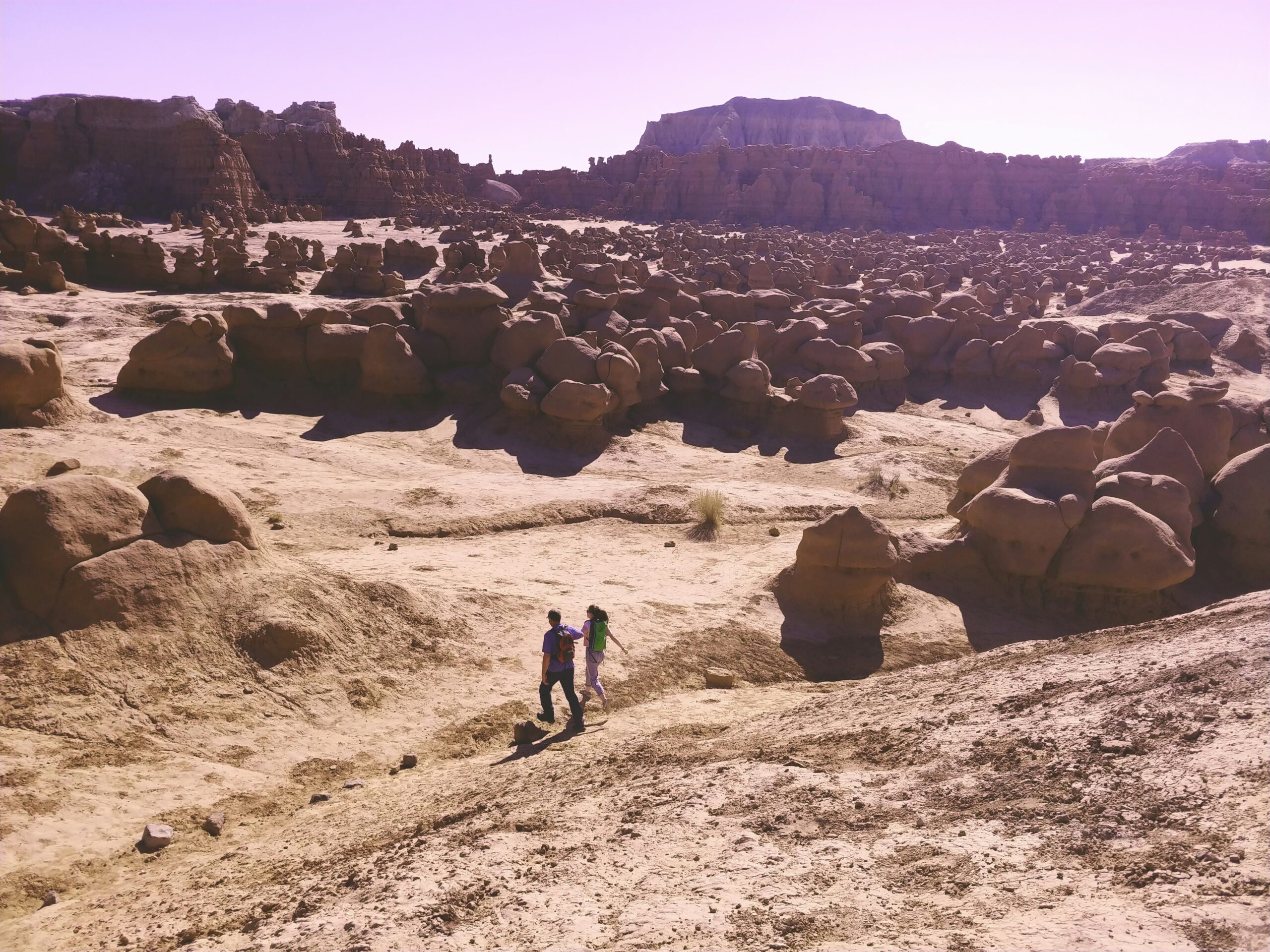
Goblin Valley State Park protects thousands of mushroom-shaped rock formations called hoodoos or “goblins” that cover the valley floor like an alien army frozen in time. This unique landscape formed through the erosion of Entrada Sandstone, the same formation that creates arches in Arches National Park.
A Playground of Stone
Unlike most Utah parks that restrict visitors to designated trails, Goblin Valley encourages exploration. Visitors can wander freely among the formations, creating their own routes through the goblins and discovering hidden valleys and unusual rock shapes. This hands-on approach makes Goblin Valley especially popular with children, who delight in climbing on formations, playing hide-and-seek among the goblins, and using their imaginations to find shapes in the rocks.
The main valley contains the highest concentration of goblins, accessed via a short trail from the observation point parking area. Three marked trails, the Carmel Canyon Loop (1.5 miles), Curtis Bench Trail (2.1 miles), and Entrada Canyon Trail (1.3 miles), explore different sections of the park, though most visitors prefer to simply wander wherever the landscape takes them.
Beyond the Goblins
The park’s backcountry offers more challenging hiking and stunning scenery beyond the main valley. The Little Wild Horse and Bell Canyon Loop (8.5 miles) ranks among Utah’s best slot canyon hikes, squeezing through narrow passages where walls tower hundreds of feet overhead. This hike can be shortened by hiking one canyon as an out-and-back route (5.5 miles to hike both canyons one way).
The slot canyons feature several sections where hikers must chimney between walls or boost each other over obstacles, adding adventure to the experience. Flash flood danger exists in slot canyons, so check weather forecasts before entering and never hike slots when rain threatens.
Wild Horse Butte rises 500 feet above the valley floor and can be climbed via an unmarked route for those comfortable with scrambling. The summit provides sweeping views across the San Rafael Swell and Henry Mountains.
9. Bonneville Salt Flats
The Bonneville Salt Flats stretch across 30,000 acres of northwestern Utah, creating one of the most surreal landscapes on Earth. This remnant of ancient Lake Bonneville features a thick crust of salt that forms an almost perfectly flat surface, appearing to extend to infinity under the right conditions.
The Science Behind the Flats
Lake Bonneville covered much of western Utah during the last ice age, reaching depths of 1,000 feet. As the climate warmed and the lake evaporated, it left behind salt and minerals that had been dissolved in the water. The salt accumulated in the lowest areas, eventually creating the salt flats visible today.
The salt crust varies in thickness from a few inches near the edges to five feet thick in the center. During winter and spring, water covers the flats, dissolving the salt crust’s surface. As this water evaporates in late spring and summer, it leaves behind a fresh layer of crystalline salt. The repeated cycle of flooding and evaporation creates the remarkably flat surface for which the area is famous.
Land Speed Racing Heritage
The Bonneville Salt Flats gained international fame as a venue for land speed racing. The flat, hard surface provides ideal conditions for high-speed runs, and numerous world speed records have been set here since racing began in 1914. Speed Week, held annually in August, attracts racers from around the world attempting to set new records in various vehicle classes.
The racing association has marked a black line on the flats that serves as a visual reference for racers and a popular target for photographers. Even when racing isn’t occurring, visitors can walk or drive onto the flats and experience the surreal environment firsthand.
Visiting the Salt Flats
The salt flats are accessible year-round, but conditions vary dramatically with the seasons. Summer and fall typically offer the best conditions for walking on the flats, when the surface is dry and firm. Winter and spring often leave the flats covered with water, creating mirror-like reflections that photographers prize but making walking impossible.
The Bonneville Salt Flats International Speedway rest area, located along Interstate 80, provides parking, restrooms, and information panels explaining the area’s geology and racing history. From here, visitors can walk onto the flats and experience the landscape’s otherworldly quality.
The flats appear deceptively small from the interstate, but walking toward the mountains reveals the true scale of the landscape. Many visitors report disorientation due to the lack of reference points; the flat white surface extends in all directions, making distance and depth difficult to judge.
Photography Tips
The salt flats create challenging photography conditions due to the extreme brightness of the white surface. Shoot during golden hour (shortly after sunrise or before sunset) when the warm light contrasts with the white salt and mountains on the horizon glow with color. Bring props or models to provide scale and interest in an otherwise featureless landscape.
The mirror effect that appears when water covers the flats creates exceptional photographic opportunities, with perfect reflections of sky and clouds. Check recent visitor reports to determine current water conditions before planning a photography trip specifically for mirror reflections.
10. Salt Lake City and Surrounding Areas
Utah’s capital and largest city combines urban sophistication with easy access to world-class skiing, hiking, and natural beauty. Salt Lake City provides an excellent base for exploring Utah’s national parks while offering museums, restaurants, shopping, and cultural experiences.
Temple Square and Mormon Heritage
Temple Square, the six-acre complex in downtown Salt Lake City, serves as the worldwide headquarters of The Church of Jesus Christ of Latter-day Saints. The Salt Lake Temple, completed in 1893 after 40 years of construction, dominates the skyline with its granite spires. While the temple interior is reserved for church members, the grounds and several visitor centers welcome the public.
The Mormon Tabernacle, home to the world-famous Tabernacle Choir at Temple Square, offers free weekly performances on Thursday evenings and Sunday mornings. The tabernacle’s exceptional acoustics allow a pin dropped at the front of the hall to be heard clearly in the back row.
Natural History Museum of Utah
The Natural History Museum of Utah, located in the foothills above the University of Utah campus, houses world-class collections of fossils, minerals, and Native American artifacts. The museum’s building alone deserves attention, designed to blend with the surrounding landscape while providing stunning views across the Salt Lake Valley.
The Past Worlds gallery displays Utah’s remarkable paleontological treasures, including complete dinosaur skeletons found within the state. Interactive exhibits explain the geological forces that created Utah’s diverse landscapes and the evolutionary history of life on Earth.
Big and Little Cottonwood Canyons
The Cottonwood Canyons, located 30 minutes from downtown Salt Lake City, provide year-round recreation opportunities. In winter, these canyons host some of North America’s premier ski resorts, including Alta, Snowbird, Brighton, and Solitude. These resorts regularly receive over 500 inches of snow per year, creating exceptional skiing and snowboarding conditions.
Summer transforms the canyons into hiking and climbing destinations. Numerous trails explore alpine lakes, meadows filled with wildflowers, and peaks exceeding 11,000 feet in elevation. The proximity of these mountains to the city makes it possible to finish work downtown and reach a trailhead for an evening hike within 45 minutes.
Lake Blanche Trail (6 miles round-trip, 2,700 feet elevation gain) provides one of the most rewarding hikes in the Cottonwood Canyons, reaching three alpine lakes surrounded by dramatic peaks. The trail is strenuous but well-maintained, and the views justify the effort.
Antelope Island State Park
Antelope Island, located in the Great Salt Lake 40 minutes north of Salt Lake City, offers a completely different landscape from Utah’s canyon country. The island hosts free-roaming bison, pronghorn antelope, bighorn sheep, and millions of migratory birds.
The 28-mile scenic drive around the island provides opportunities to spot wildlife, swim in the salty water, and hike trails that offer views across the lake to distant mountain ranges. The Great Salt Lake contains salt concentrations up to eight times higher than ocean water, providing enough buoyancy that swimmers float effortlessly.
Spring and fall migrations bring millions of shorebirds to the island, making it one of the best birdwatching destinations in the western United States. The Fielding Garr Ranch, located on the island’s southern end, operates as a working ranch and museum, preserving buildings that date to the 1840s.
Hidden Gems in Utah
Beyond the major national parks and popular destinations, Utah harbors numerous lesser-known locations that offer exceptional beauty with fewer crowds.
Coral Pink Sand Dunes State Park
Coral Pink Sand Dunes State Park protects a field of pink-hued dunes that can reach heights of several hundred feet. These dunes formed from Navajo Sandstone eroded from nearby cliffs, with iron oxide creating the distinctive coral color. Wind funneling through a notch in the surrounding cliffs creates the conditions necessary for dune formation and maintenance.
The park allows off-highway vehicle use in designated areas, attracting ATV and dirt bike enthusiasts. However, a significant portion of the park remains closed to vehicles, providing excellent hiking and sandboarding opportunities. The soft sand makes for challenging walking but creates a playground for children and photographers.
Escalante River and Grand Staircase-Escalante National Monument
The town of Escalante serves as the gateway to the Grand Staircase-Escalante National Monument, a vast landscape of slot canyons, plateaus, natural arches, and remote wilderness. The Escalante River and its tributaries carved numerous slot canyons through colorful sandstone, creating some of Utah’s best canyoneering opportunities.
Zebra Slot Canyon and Peek-a-boo Gulch rank among the area’s most beautiful canyons, featuring striped walls, narrow passages, and dramatic light beams. These canyons require some scrambling and can involve muddy conditions, but they offer experiences that rival more famous locations without the crowds.
Calf Creek Falls Recreation Area provides easier access to the Escalante region’s beauty. The Lower Calf Creek Falls trail (6 miles round-trip) follows a perennial stream through a spectacular canyon to a 126-foot waterfall. Ancient granaries, petroglyphs, and beaver ponds along the trail add interest to the journey.
Little Sahara Recreation Area
Little Sahara Recreation Area encompasses 60,000 acres of dunes located in central Utah. Unlike Coral Pink Sand Dunes, Little Sahara is entirely open to OHV use, making it a premier destination for ATV riders, dirt bikers, and dune buggy enthusiasts. The dunes can reach heights of 700 feet, providing challenging terrain and spectacular views from the summits.
Jordanelle and Rockport State Parks
Jordanelle and Rockport State Parks, located east of Salt Lake City in the Wasatch Mountains, offer water-based recreation in scenic alpine settings. These reservoirs provide opportunities for boating, fishing, paddleboarding, and swimming, with campgrounds and day-use areas along their shores.
Jordanelle Reservoir, the larger of the two, features a rock beach at the Hailstone day-use area that has become popular with families. The Provo River flows through both reservoirs, creating excellent trout fishing opportunities.
Fantasy Canyon
Fantasy Canyon, located in eastern Utah near Vernal, protects a small area of intricately eroded rock formations that resemble sculptures. The formations developed in mudstone and sandstone of the Eocene-aged Wasatch Formation, carved by wind and water into fantastical shapes that inspired the area’s name.
A short trail loops through the canyon, providing close views of formations with descriptive names like “Flying Dragon,” “Witch’s Boot,” and “Screaming Demon.” The small size of Fantasy Canyon and its remote location keep visitation low, though the area attracts photographers who appreciate the unique formations and dramatic lighting possibilities.
Paria Canyon-Vermilion Cliffs Wilderness
The Wave, located in the Paria Canyon-Vermilion Cliffs Wilderness on the Utah-Arizona border, ranks as one of the most coveted hiking permits in the United States. This geological formation features undulating patterns of layered sandstone in shades of pink, orange, and yellow, creating a landscape that appears almost artificially designed.
Access to The Wave requires a permit obtained through a lottery system administered by the Bureau of Land Management. Only 64 people per day receive permits (48 through an online lottery held four months in advance, and 16 through a walk-in lottery held the day before). The high demand reflects both the area’s beauty and the importance of limiting visitation to protect the delicate sandstone formations.
While The Wave draws most attention, the surrounding area offers numerous other slot canyons, arches, and colorful rock formations that receive far fewer visitors. White Pocket, another formation within the wilderness area, provides similar photographic opportunities without the permit requirements, though accessing it requires navigating difficult dirt roads.
Bear Lake
Bear Lake, straddling the Utah-Idaho border, earns its nickname “Caribbean of the Rockies” due to its striking turquoise-blue water. This color results from limestone particles suspended in the water, which reflect blue and green wavelengths of light. The 20-mile-long lake offers beaches, camping, boating, and fishing for cutthroat trout.
The area surrounding Bear Lake draws visitors for water sports in summer and snowmobiling in winter. Garden City, the main town on the lake’s Utah shore, is famous for raspberry shakes a local tradition that dates back decades. Numerous stands compete to serve the best shakes using raspberries grown in the surrounding area.
Millcreek Canyon
Millcreek Canyon, located 15 minutes from downtown Salt Lake City, provides easy access to hiking, mountain biking, and nature experiences. Unlike the nearby Cottonwood Canyons, Millcreek allows dogs on-leash and alternates days for mountain biking, making it particularly popular with locals.
The canyon features numerous trailheads providing access to waterfalls, alpine lakes, and ridge-top views. Donut Falls Trail (1.8 miles round-trip) leads to a waterfall that flows through a hole in the rock, creating a “donut” shape. This family-friendly trail becomes crowded on weekends but offers a quick nature escape from the city.
Lake Blanche’s less-crowded alternative, Dog Lake (5 miles round-trip), provides alpine scenery and wildflower meadows without the extreme elevation gain of other Wasatch hikes. The trail is suitable for most fitness levels and offers excellent autumn foliage viewing.
Snow Canyon State Park
Snow Canyon State Park, located 10 miles north of St. George in southwestern Utah, showcases red and white Navajo Sandstone formations, ancient lava flows, and colorful desert scenery. The park’s lower elevation makes it an ideal winter destination when higher-elevation parks experience snow and cold.
Hiking trails wind through lava tubes, across petrified dunes, and up to viewpoints overlooking the canyon. The Jenny’s Canyon Trail (1 mile round-trip) squeezes through a narrow slot canyon accessible to hikers of all abilities. The Pioneer Names Trail features signatures carved into the canyon walls by early settlers passing through the area.
Rock climbing opportunities abound in Snow Canyon, with routes ranging from beginner-friendly to expert-level. The park’s sandstone walls provide excellent friction for climbing, though summer heat limits the climbing season to cooler months.
What to Do in Utah: Activities Beyond Sightseeing
Utah’s diverse landscapes support an incredible range of outdoor activities beyond hiking and scenic viewing. Understanding the options helps visitors plan trips that match their interests and abilities.
Rock Climbing and Canyoneering
Utah ranks among the world’s premier climbing destinations, offering everything from traditional crack climbing in Indian Creek to sport climbing in St. George. Moab provides access to countless climbing areas, including the famous Potash Road towers and the Fisher Towers, which feature spectacular multi-pitch routes on unique Cutler Sandstone formations.
Canyoneering, the sport of descending canyons using rappelling, swimming, and scrambling techniques, originated in Utah’s slot canyons. Technical canyons like The Subway in Zion and the Escalante slot canyons require specialized equipment and knowledge, but many non-technical canyons offer adventurous experiences without ropes. Hiring guides provides safe introductions to canyoneering while supporting local businesses.
Mountain Biking
Moab has become synonymous with mountain biking, hosting trails that range from easy scenic rides to extremely technical challenges. The Slickrock Bike Trail, a 10.5-mile loop across petrified dunes, tests riders’ technical skills and endurance while providing spectacular views. The trail’s grippy sandstone surface allows traction on seemingly impossible grades.
The Whole Enchilada, descending from the La Sal Mountains to the Colorado River, offers 8,000 feet of vertical descent through five distinct ecological zones. This 26-mile trail ranks among the most epic rides in North America, combining high alpine terrain, aspen forests, red rock formations, and desert landscapes into a single unforgettable journey.
Beyond Moab, Park City claims the title of “Mountain Bike Capital of the World,” with over 450 miles of trails accessible from downtown. The town’s mining history left behind a network of old roads and trails that have been transformed into world-class singletrack.
Skiing and Snowboarding
Utah’s tagline, “The Greatest Snow on Earth,” isn’t mere marketing; the state’s unique weather patterns create light, dry powder snow that’s ideal for skiing and snowboarding. The Wasatch Mountains regularly receive 500+ inches of snow annually, with a base-area average snowfall that exceeds most other North American destinations.
Alta and Snowbird in Little Cottonwood Canyon offer steep terrain, deep powder, and challenging conditions that attract expert skiers. Alta maintains its status as a ski-only resort, not allowing snowboarders. Park City Mountain Resort, created by connecting Park City and Canyons resorts, claims the title of the largest ski resort in the United States with over 7,300 acres of skiable terrain.
Powder Mountain in Eden takes a different approach, limiting ticket sales to preserve powder snow and reduce crowds. This community-owned resort offers unique terrain and a relaxed atmosphere that appeals to those seeking an alternative to crowded mega-resorts.
River Rafting
Utah’s rivers provide adventures ranging from peaceful float trips suitable for families to challenging whitewater expeditions. The Colorado River through Cataract Canyon features rapids rated Class IV-V during high water, creating one of the most thrilling multi-day rafting trips in North America. These trips typically require 3-6 days and pass through spectacular canyon scenery within Canyonlands National Park.
The Green River through Desolation Canyon offers a more relaxed experience, with Class II-III rapids interspersed with calm water perfect for swimming and enjoying the scenery. This 84-mile section can be completed in 5-7 days, with limited permit requirements and exceptional opportunities for solitude.
The San Juan River provides access to remote archaeological sites, including well-preserved Ancestral Puebloan ruins visible from the river. This scenic float trip combines geology, archaeology, and desert beauty into a unique river experience.
Hot Air Ballooning
Hot air balloon rides over Park City, Heber Valley, and other scenic areas provide unique perspectives on Utah’s landscapes. Flights typically occur at sunrise when winds are calm and lighting is optimal for photography. Drifting silently above valleys, mountains, and red rock formations creates a peaceful, almost meditative experience.
Several companies offer balloon flights over Monument Valley, providing views of the iconic buttes from above. These flights time their launches to coincide with sunrise, when the formations glow in warm light and long shadows create dramatic contrasts.
Horseback Riding
Exploring Utah on horseback connects visitors with the state’s cowboy heritage while providing access to areas difficult to reach on foot. Outfitters throughout Utah offer everything from one-hour rides to multi-day pack trips into the backcountry.
Monument Valley horseback tours, led by Navajo guides, provide culturally rich experiences while exploring landscapes made famous in classic Western films. These rides pass through areas closed to independent travelers, including backcountry viewpoints and rock art sites.
Ranch stays allow visitors to experience working ranch life, participating in cattle drives, herding, and other ranch activities. Several operating ranches in central and southern Utah offer guest programs that combine comfortable accommodations with authentic Western experiences.
Scenic Flights
Small aircraft and helicopter tours provide access to remote areas and perspectives impossible to achieve from the ground. Flights over Canyonlands, Monument Valley, and Lake Powell reveal the true scale and complexity of these landscapes while covering distances that would require days of driving.
These flights represent significant financial investments but offer unparalleled photographic opportunities and experiences. Some tours land in remote locations, combining aerial perspectives with ground-based exploration.
Utah Travel Tips: Planning Your Perfect Trip
Successful Utah trips require careful planning, particularly regarding timing, logistics, and physical preparation. These practical tips help visitors avoid common mistakes and maximize their experiences.
Best Time to Visit Utah
Utah’s climate varies dramatically by elevation and season, making timing crucial for trip planning. Spring (April-May) and fall (September-October) generally provide the best conditions for visiting the national parks, with moderate temperatures, smaller crowds than summer, and beautiful lighting for photography.
Summer brings intense heat to southern Utah’s desert parks, with temperatures regularly exceeding 100°F. However, summer is ideal for higher-elevation destinations including the Wasatch Mountains, where temperatures remain comfortable and wildflowers bloom in alpine meadows. Summer also provides the longest daylight hours, allowing more time for activities.
Winter transforms Utah into a skiing paradise, with the Wasatch Mountains receiving consistent snowfall. Lower-elevation parks like Zion and Capitol Reef remain accessible and beautiful in winter, though some facilities close. Winter crowds are minimal except at ski resorts, and snow-covered red rocks create stunning photographic opportunities.
Each season offers distinct advantages:
- Spring: Wildflowers bloom, waterfalls flow at peak volume, temperatures are mild, and crowds remain manageable before summer vacation season
- Summer: All facilities operate, long daylight hours maximize adventure time, alpine areas become accessible, though crowds peak and desert temperatures soar
- Fall: Arguably the best season with perfect temperatures, autumn colors in mountain areas, and decreasing crowds after Labor Day
- Winter: Solitude in national parks, world-class skiing, unique photography opportunities, though some roads close and hiking options decrease
How Much Time Do You Need?
Utah’s vast size and dispersed attractions require realistic time planning. Many first-time visitors underestimate distances and try to see too much in too little time, resulting in rushed experiences and excessive driving.
For a comprehensive tour of the Mighty Five national parks, allow at least 10-14 days. This timeframe permits visiting each park properly while allowing for travel days and weather flexibility. Shorter trips should focus on 2-3 parks in the same region rather than attempting to cover the entire state.
A focused trip to one area provides deeper experiences and less driving. For example, basing yourself in Moab allows easy access to Arches and Canyonlands National Parks, Dead Horse Point State Park, and numerous mountain biking and climbing areas, all within 45 minutes of town.
Sample itinerary for a one-week trip focusing on southern Utah’s parks:
- Day 1: Arrive in Las Vegas, drive to Zion (2.5 hours), afternoon in the park
- Day 2: Full day in Zion (Angels Landing or Narrows)
- Day 3: Morning in Zion, drive to Bryce Canyon (1.5 hours), sunset at Bryce
- Day 4: Sunrise and morning at Bryce, drive to Capitol Reef (2 hours), explore the Fruita area
- Day 5: Capitol Reef scenic drive, continue to Moab (3.5 hours)
- Day 6: Arches National Park
- Day 7: Canyonlands Island in the Sky, depart from Moab or return to Las Vegas
Lodging Strategies
Accommodation availability can be challenging near popular parks, especially during peak season (May-October). Book lodging as early as possible; six months in advance isn’t excessive for in-park lodging or gateway towns during peak season.
Gateway towns near each park provide the closest lodging options:
- Zion: Springdale (just outside park entrance) or Hurricane/St. George (45 minutes away)
- Bryce Canyon: Bryce Canyon City (right outside the park), Tropic, or Panguitch
- Capitol Reef: Torrey (10 minutes from park)
- Arches/Canyonlands: Moab (30 minutes from Arches, 45 minutes from Island in the Sky)
- Monument Valley: Kayenta, Arizona (25 minutes) or Mexican Hat, Utah (20 minutes)
Camping provides excellent value and authentic experiences, with campgrounds inside most national parks and numerous options in surrounding areas. National park campgrounds require reservations (available six months in advance through Recreation.gov) and typically fill immediately upon release. Arrive at first-come, first-served campgrounds early by 9 AM or earlier during peak season.
Transportation and Driving
Renting a car provides essential flexibility for exploring Utah. Most visitors fly into Salt Lake City or Las Vegas and drive to the national parks. Las Vegas sits closer to Zion and offers competitive rental car rates, while Salt Lake City provides better access to northern Utah destinations.
Utah’s roads range from interstate highways to rough dirt tracks requiring high-clearance 4WD vehicles. Major highways connecting national parks are paved and well-maintained, suitable for all vehicles. However, many secondary attractions require dirt roads that may be impassable during or after rain.
Gas stations are sparse in rural Utah fill up whenever you see a station. Towns can be 100+ miles apart, and running out of fuel in remote areas creates dangerous situations. Carry extra water, food, and supplies when driving remote roads.
Cell phone service is unreliable throughout much of rural Utah. Download maps, directions, and trail information before leaving service areas. Consider purchasing paper maps as backup navigation tools.
Permits and Reservations
Several Utah attractions now require permits or timed-entry reservations to manage crowds and protect resources:
Arches National Park: Timed-entry reservations required April-October, 7 AM-4 PM. Reserve up to three months in advance at Recreation.gov. Some same-day permits become available at 6 PM the day before.
Angels Landing (Zion): Permit required year-round. Apply through the lottery system seasonal lottery held months in advance, plus a day-before lottery. Visit Recreation.gov for current procedures.
The Subway (Zion): Permit required for both top-down technical route and bottom-up hiking route. Advance lottery plus day-before permits are available through Zion’s permit system.
The Wave (Paria Canyon-Vermilion Cliffs): Online lottery held four months in advance, walk-in lottery held the day before. Only 64 permits are issued daily. High demand makes permits difficult to obtain.
White Rim Road (Canyonlands): Overnight camping permits required, available four months in advance. Day-use permits required for vehicle or bike tours, available same-day at the visitor center.
Apply for permits well in advance, and have backup plans if you don’t receive your preferred permits.
Safety Considerations
Utah’s desert environment creates hazards unfamiliar to many visitors. Heat, dehydration, flash floods, and rugged terrain contribute to numerous rescue operations each year.
Heat and Hydration: Desert heat kills. Carry and drink more water than you think necessary, one gallon per person per day minimum, more for strenuous activities. Recognize heat exhaustion symptoms, including dizziness, nausea, headache, and confusion. Avoid strenuous hiking during midday heat (10 AM-4 PM) in summer.
Flash Floods: Narrow canyons can flood with little warning during thunderstorms. Check weather forecasts before entering slot canyons, and avoid them entirely when rain threatens. Flash floods can occur even when skies are clear locally if storms rage in the mountains upstream.
Navigation: Trails in Utah often cross slickrock where cairns (rock piles) mark routes. Cairns can be difficult to spot, and following the wrong cairns leads hikers astray. Carry GPS devices or downloaded maps, and turn back if uncertain about the route.
Wildlife: Utah hosts rattlesnakes, scorpions, and black widow spiders. Watch where you place your hands and feet, especially around rocks and logs. Mountain lion sightings occur occasionally. Never hike alone in areas with recent sightings, supervise children closely, and fight back if attacked.
Altitude: Many Utah destinations sit above 8,000 feet in elevation. Visitors from sea level may experience altitude sickness, including headaches, shortness of breath, and fatigue. Ascend gradually, stay hydrated, and avoid alcohol for the first day at altitude.
What to Pack
Packing appropriately ensures comfort and safety during Utah adventures. Essential items include:
Clothing: Layers work best for Utah’s temperature fluctuations. Mornings can be cold even in summer, with temperatures rising 40-50°F by afternoon. Pack moisture-wicking base layers, insulating mid-layers, and weatherproof outer layers. Sun protection is critical; wear wide-brimmed hats, sunglasses with UV protection, and long-sleeved shirts.
Footwear: Hiking boots or sturdy trail shoes with ankle support and grippy soles are essential. Many trails cross slickrock where traction is crucial. Break in new boots before your trip to avoid blisters.
Sun Protection: Utah’s high elevation and clear skies create intense sun exposure. Apply broad-spectrum sunscreen (SPF 30+) regularly, even on cloudy days. Lip balm with SPF prevents painful chapped lips.
Hydration Systems: Carry more water than you expect to need. Hydration bladders (CamelBak-style) encourage regular drinking and free your hands for scrambling. Bring extra bottles as backup.
Navigation Tools: Download offline maps to your smartphone, carry paper maps as backup, and consider GPS devices for complex backcountry routes. Fully charged portable battery banks keep phones operational for navigation and emergency communication.
Emergency Supplies: First aid kit, headlamp with extra batteries, emergency blanket, fire-starting materials, and a knife form a basic emergency kit. Add personal medications and any specific items your group might need.
Photography Equipment: Utah’s incredible landscapes demand camera gear. Bring tripods for sunrise/sunset shooting, lens cleaning supplies (dust is constant), polarizing filters to enhance colors and reduce reflections, and plenty of memory cards.
Respecting the Environment
Utah’s popularity threatens the very features that attract visitors. Practice Leave No Trace principles to preserve these landscapes for future generations:
Stay on Trails: Biological soil crusts (cryptobiotic soil) take decades to regenerate once damaged. These living crusts prevent erosion and support desert ecosystems. Stay on designated trails and slickrock surfaces, never cutting switchbacks or creating social trails.
Pack Out Everything: “Leave No Trace” means exactly that, pack out all trash, including biodegradable items like apple cores and orange peels. Dispose of human waste properly using catholes (6-8 inches deep, 200 feet from water) or carry it out in WAG bags where required.
Respect Wildlife: Never feed animals (it’s illegal and harmful). Observe wildlife from safe distances using binoculars or telephoto lenses. Store food in vehicles or bear canisters to prevent animals from becoming food-conditioned.
Preserve Cultural Sites: Federal law protects archaeological sites, including rock art, ruins, and artifacts. Never touch rock art (skin oils damage it), climb on ruins, or remove artifacts. Photograph these treasures, but leave them undisturbed.
Minimize Campfire Impacts: Use camp stoves instead of fires when possible. Where fires are permitted, use established fire rings and burn only small sticks collected from the ground. Never leave fires unattended, and ensure they’re completely extinguished before leaving.
Photography Tips
Utah’s landscapes create both incredible opportunities and technical challenges for photographers.
Golden Hours: The hour after sunrise and before sunset provides the warmest, most dramatic light. Red rock formations glow during these times, and long shadows add depth and texture to photographs. Plan to be at your shooting location 30-45 minutes before sunrise or sunset.
Midday Challenges: Harsh midday light creates strong contrasts and washed-out colors. Use this time for slot canyons, where indirect light and light beams create magical conditions, or scout locations for golden hour shoots.
Weather Adds Drama: Clouds, storms, and dramatic weather create more interesting photographs than clear blue skies. Don’t pack up your camera when the weather turns bad, some of the most stunning images capture storms, rainbows, and dynamic clouds.
Include Scale: Utah’s vast landscapes can appear flat and dimensionless in photographs without elements showing scale. Include people, vehicles, or known objects to convey the true size of formations.
Protect Your Gear: Dust penetrates everything in Utah. Use protective covers for cameras and lenses, change lenses inside vehicles or sheltered areas, and clean gear regularly. Microfiber cloths and rocket blowers remove dust without scratching lenses.
Utah National Parks Travel Guide: Maximizing Your Park Experiences
Each of Utah’s national parks has unique characteristics that influence how to approach your visit.
Zion: Arrive extremely early (before 7 AM) or after 3 PM to find parking. The shuttle system is mandatory but efficient. Book popular hikes like Angels Landing and The Narrows early in your planning. Springdale offers excellent restaurants and accommodations just outside the park entrance.
Bryce Canyon: Higher elevation means cooler temperatures bring layers even in summer. The main amphitheater viewpoints are close together, making it possible to see Bryce’s highlights in half a day, though hiking among the hoodoos provides richer experiences. Bryce’s dark skies make it exceptional for stargazing. Stay for a ranger-led astronomy program if possible.
Capitol Reef: This is the most underrated of the Mighty Five. Take time to drive the scenic road, pick fruit in the historic orchards (in season), and explore the park’s many hiking trails. The Gifford Homestead’s fresh-baked pies shouldn’t be missed. Don’t skip Cathedral Valley if you have a capable vehicle; it’s spectacularly beautiful and nearly deserted.
Arches: Secure timed-entry reservations well in advance for peak season. Hike to Delicate Arch early or late to avoid crowds and heat. Explore lesser-known areas like the Devil’s Garden primitive loop for solitude. Stay until sunset when the arches glow against darkening skies.
Canyonlands: Island in the Sky provides the easiest access and most dramatic overlooks. The Needles District rewards those willing to drive farther with exceptional hiking and smaller crowds. Don’t attempt The Maze unless you have appropriate vehicles, experience, and supplies. It’s genuinely remote and challenging.
Budget Considerations
Utah trips can range from budget-friendly to luxury experiences, depending on choices made regarding accommodations, dining, and activities.
National Park Entrance Fees: Individual park passes cost $20-35 per vehicle for seven days. The America the Beautiful Annual Pass ($80) covers entrance to all national parks and federal recreation areas for one year, an excellent value if visiting multiple parks.
Camping vs. Hotels: Campsite fees range from $15-35 per night, while hotels near parks typically charge $150-300+ per night during peak season. Dispersed camping on Bureau of Land Management and National Forest lands costs nothing but requires more research and preparation.
Food: Restaurants near major parks charge premium prices. Grocery shopping in larger towns (Moab, St. George, Cedar City) and preparing your own meals significantly reduces costs. Pack coolers with ice and store perishables safely.
Guided Tours: While guided tours add expense ($100-300+ per person), they provide expertise, access to areas requiring permits, and enhanced safety for technical activities like canyoneering and rock climbing.
Fuel: Budget more for fuel than normal road trips, gas prices are higher in remote areas, and the distances between attractions add up quickly.
Frequently Asked Questions About Visiting Utah
What Are the Most Visited Places in Utah?
Zion National Park ranks as Utah’s most visited destination, attracting over 4.5 million visitors annually. The park’s accessibility from Las Vegas (2.5 hours) and stunning scenery contribute to its popularity. Following Zion, the most visited places in Utah include:
- Zion National Park – The Virgin River carved spectacular canyons that draw visitors worldwide
- Bryce Canyon National Park – Unique hoodoo formations create otherworldly landscapes
- Arches National Park – Over 2,000 natural stone arches, including the iconic Delicate Arch
- Temple Square in Salt Lake City – The cultural and religious center of the LDS Church attracts millions annually
- Park City – World-class skiing in winter and mountain activities year-round
- Canyonlands National Park – Though receiving fewer visitors than the other “Mighty Five,” it still draws hundreds of thousands annually
- Capitol Reef National Park – The least visited of the five national parks but gaining popularity
- Dead Horse Point State Park – Spectacular views rivaling any national park
- Antelope Island State Park – Unique wildlife viewing and Great Salt Lake access
- Moab – The gateway town for Arches and Canyonlands serves as an adventure sports hub
These destinations’ popularity means crowds, especially during peak season (May-October). Visiting during shoulder seasons (April, November) or winter provides similar experiences with fewer people.
What Not to Miss in Utah?
While Utah offers countless attractions, certain experiences define visits to the state and shouldn’t be skipped:
Zion Canyon – Whether hiking Angels Landing, wading through The Narrows, or simply riding the shuttle to admire towering walls, Zion Canyon provides unforgettable experiences. The sheer scale of the cliffs rising 2,000 feet from the valley floor must be experienced firsthand.
Bryce Amphitheater at Sunrise – The hoodoos glowing in early morning light create one of nature’s most spectacular shows. Bundle up (it’s cold at 8,000 feet elevation in the morning) and position yourself at Sunrise Point or Bryce Point before dawn.
Delicate Arch – Utah’s most iconic landmark appears on license plates and tourism materials for good reason. The hike is challenging, especially in summer heat, but standing beneath this freestanding arch as the sun sets makes the effort worthwhile.
Dead Horse Point Overlook – This viewpoint provides 100-mile vistas encompassing Canyonlands National Park, the Colorado River, and the La Sal Mountains. Many visitors consider it superior to any Canyonlands viewpoint, and it doesn’t require timed-entry reservations.
Monument Valley – The massive buttes and mesas rising from the desert floor create the quintessential Western landscape. Hiring a Navajo guide provides access to restricted areas and cultural insights that enrich the experience.
Historic Fruita Orchards (Capitol Reef) – Pick fresh fruit in season and enjoy fresh-baked pie at the Gifford Homestead. This unique combination of natural beauty and living history distinguishes Capitol Reef from other parks.
Goblin Valley – The freedom to explore among thousands of hoodoos, climbing and discovering hidden valleys, creates especially memorable experiences for children but delights visitors of all ages.
A Slot Canyon Experience – Whether hiking Little Wild Horse Canyon near Goblin Valley, The Narrows in Zion, or hiring a guide for technical canyoneering, squeezing through narrow passages between towering walls exemplifies the Utah adventure.
Dark Sky Stargazing – Utah’s remote locations and clear skies create exceptional stargazing opportunities. Bryce Canyon, Capitol Reef, and Natural Bridges National Monument offer ranger-led astronomy programs and views of the Milky Way impossible to see from populated areas.
Local Food Experiences – Don’t miss regional specialties like fry sauce (a Utah condiment combining ketchup and mayonnaise), pastrami burgers, raspberry shakes at Bear Lake, and funeral potatoes (a cheesy potato casserole served at Mormon gatherings).
Is 3 Days Enough for Utah National Parks?
Three days allows visitors to experience 2-3 parks in one region, but it’s not enough to see all five national parks properly. Utah’s Mighty Five parks span over 300 miles from north to south and 250 miles east to west, making comprehensive coverage impossible in three days without exhausting travel schedules.
For a three-day Utah national parks trip, focus on parks in the same geographic area:
Option 1: Southern Parks Circuit (Zion and Bryce Canyon)
- Day 1: Arrive at Zion, explore the canyon on the shuttle, hike Emerald Pools or Canyon Overlook
- Day 2: Full day in Zion hiking Angels Landing (with permit) or The Narrows
- Day 3: Drive to Bryce Canyon (1.5 hours), hike into the amphitheater via Navajo Loop/Queen’s Garden, and enjoy the sunset
Option 2: Moab-Based Adventure (Arches and Canyonlands)
- Day 1: Arches National Park, hike to Delicate Arch, explore Devil’s Garden
- Day 2: Canyonlands Island in the Sky, visit Grand View Point and Mesa Arch, consider White Rim Overlook
- Day 3: Additional time in either park, Dead Horse Point State Park, or Moab activities (mountain biking, rock climbing)
Option 3: Comprehensive Quick Tour (rushed but possible)
- Day 1: Zion National Park highlights
- Day 2: Drive to Bryce Canyon (morning), then Capitol Reef (afternoon/evening)
- Day 3: Drive to Moab, visit Arches or Canyonlands
The third option involves significant driving (6+ hours total) and provides only brief tastes of each park. While technically achieving visits to multiple parks, this approach sacrifices depth for breadth.
For visitors with limited time, quality beats quantity. Spending three days thoroughly exploring one or two parks creates more meaningful experiences than rushing through four or five park,s checking boxes. The parks’ unique characteristics deserve attention, and some top attractions require several hours or full days to properly experience.
If you have more time, a week to ten days allows comfortable exploration of all five national parks plus surrounding attractions. Two weeks provides enough time to truly experience each park, take side trips to hidden gems, and avoid feeling rushed.
What Should I See First Time in Utah?
First-time visitors to Utah should prioritize experiences that showcase the state’s unique geological features and natural beauty. The ideal first-time itinerary depends on available time, arrival location, and season, but certain destinations provide the best introduction to Utah’s wonders.
For One Week: Southern Parks Circuit
Begin in Las Vegas (major airport, good rental car rates) and create a loop through southern Utah’s national parks:
- Zion National Park (2 days) – Start here because it’s closest to Las Vegas and provides a spectacular introduction to Utah’s canyon country. The dramatic cliffs and accessible hiking establish expectations for the journey ahead.
- Bryce Canyon National Park (1 day) – The unique hoodoo formations differ completely from Zion, demonstrating Utah’s geological diversity. A full day allows time to hike among the formations and enjoy multiple viewpoints.
- Capitol Reef National Park (1-2 days) – Often overlooked by first-timers, Capitol Reef offers beautiful scenery with smaller crowds. The scenic drive and Fruita historic district provide variety from pure hiking.
- Moab/Arches/Canyonlands (2-3 days) – End in Moab, experiencing Arches’ iconic formations and Canyonlands’ vast vistas. The town provides excellent restaurants and services after several days in more remote areas.
For a Long Weekend: Zion and Bryce
With only 3-4 days, focus entirely on Zion and Bryce Canyon. These parks sit close together (90 minutes apart) and offer dramatically different landscapes. This approach provides quality time in each park without exhausting drive times.
For Two Weeks: Comprehensive Utah Experience
Two weeks allows inclusion of Salt Lake City, the Cottonwood Canyon ski areas (winter) or hiking (summer), Monument Valley, Goblin Valley, and other hidden gems between the major parks. This timeframe permits a more relaxed pace with flexibility for weather and spontaneous discoveries.
Must-See Highlights for First-Timers:
- Hiking (or at least viewing) Delicate Arch
- Walking among Bryce Canyon’s hoodoos
- Experiencing The Narrows or Angels Landing in Zion
- Watching the sunset from Dead Horse Point
- Driving through Monument Valley
- Exploring a slot canyon (Little Wild Horse Canyon is accessible and doesn’t require permits)
What First-Timers Should Know:
- Distances are vast. Utah is a large state, and parks are far apart
- Reservations are essential for popular activities and accommodations during peak season
- The weather varies dramatically by elevation and season, so pack layers
- Cell service is unreliable. Download maps and information before entering remote areas
- Early starts beat crowds and heat; be at the railheads by 7 AM during summer
- The parks are genuinely wild, so prepare properly with water, sun protection, and navigation tools
- Respect fragile environments, stay on trails, and follow Leave No Trace principles
First-time visitors often underestimate the physical demands of Utah’s hiking trails. The combination of altitude, heat, and steep terrain challenges even fit individuals. Start with shorter, easier hikes to gauge your abilities before attempting strenuous trails like Angels Landing.
Your Utah Adventure Awaits
Utah stands apart from other American destinations, offering landscapes that seem borrowed from alien planets, outdoor adventures for all skill levels, and natural beauty that inspires awe with every visit. From the towering cliffs of Zion to the delicate arches of Moab, from the snow-covered peaks of the Wasatch to the otherworldly hoodoos of Bryce Canyon, Utah delivers experiences that stay with travelers forever.
The top 10 places to visit in Utah featured in this guide provide starting points for exploration, but they barely scratch the surface of what this remarkable state offers. Hidden gems wait around every corner, quiet trails lead to spectacular viewpoints, and slot canyons known only to locals hold wonders rivaling any famous destination.
Planning your Utah adventure requires research, flexibility, and realistic expectations about distances and timing. Book accommodations early, secure necessary permits, prepare for variable weather, and allow more time than you think necessary. Utah deserves patience and attention. The state’s beauty unfolds gradually, revealing layers of geological history, ecological diversity, and natural artistry that become more impressive the longer you explore.
Whether you’re drawn to Utah for its national parks, skiing, mountain biking, rock climbing, photography, or simply to disconnect from daily life and reconnect with nature, the state delivers. Each season offers different opportunities, every region presents distinct landscapes, and return visits reveal discoveries even in familiar places.
Start planning your Utah adventure today, research parks and activities, study maps, book accommodations, and prepare for the trip of a lifetime. The red rocks, alpine peaks, slot canyons, and star-filled skies await. Utah’s natural wonders have endured for millions of years; now it’s your turn to experience them and create memories that will last just as long.